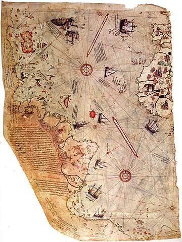
The Piri Reis Map is a world map created by the Ottoman-Turkish admiral and cartographer Piri Reis in 1513. It is known for its inclusion of the coastlines of South America and Antarctica, which were not officially discovered until centuries later. The map was created using numerous sources, including maps from ancient Greece, China, and India, as well as contemporary Portuguese maps.
The accuracy of the Piri Reis Map has been the subject of much debate among scholars and historians. Some believe that the inclusion of Antarctica suggests that Piri Reis had access to ancient maps or knowledge that was lost over time, while others argue that it is simply a coincidence or an error.
Comments